

Technique
Mathematical Model Predication
Electromagnetics extract information from the subsurface.
Utilizing this instrument provides the
optimum analysis available for water locating.
Simple: Water collects in fractures -
If there is any water beneath your property,
it would collect more readily in porous / fractured earth.
There is no other method or web page that has
duplicated/paralleled our successes consistently.
Audio “Savings”
Technique: Electro Magnetic Soundings:
Mathematically images the major geomorphic expressions
revealing the geoeletric signature for fracturing.
See what you are drilling into, (color) mathematical X-
of your property.
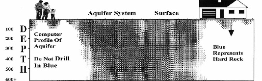
Aquifer: geologic formation of porous granitics / fracture systems that contain a degree of water.
Below; Black represents porous / fractured earth.
White represents HARD ROCK

Above: Cross Section of The Earth, a Vertical Slice -
Cross section view, mathematical X-
aquifer system in subsurface.
A cross section is like cutting an apple vertical in half
and viewing the inner mechanical fabric.
It's very simple, like an X-
-
If there is any water beneath your property,
it would collect more readily within the black area.
The heart of the black area should be the approximate drilling target for your water well.
Black arrow in the chart shows the area where a water witcher (dowser), would select for drilling. Upper right hand corner. Not in the optimum area.
Only computer technology can image the geometry of your subsurface like an X-
*The Computer Scan shows you the drilling target, where to drill for the potential of water and the Computer Scan will show you where not to drill.
Computerized electronic instrumentation generates
more coherent subsurface geological data.
With this information you eliminate misleading advice based on
inaccurate or inappropriate surface studies.
You then can make better informed drilling decisions, and you
will be able to pinpoint your drilling targets more precisely.
Reliable Affordable Economical
WaterLocating.Com
760 . 742 . 3727

| Scientific |
| Sprinkler |
| Videos |
| Videos 1,2,3,4 |
| Vista Ca 2014 |
| Drillers Testify |
| Ramona Videos |
| Video 1 of 4 How It Works (Important) |
| Video 2 of 4 Lineament Analysis |
| Video 3 of 4 Water-Witching & EKS |
| Video 4 of 4 Aquifer Geometrics |
| Vista Video |
| Testimonial |
| San Diego |
| Riverside |
| Los Angeles |
| Alpine |
| Bonsall |
| Descanco |
| El Cajon |
| Escondido |
| Fallbrook |
| Jamul |
| Julian |
| Lakeside |
| Pauma Valley |
| Poway |
| Rainbow |
| Ramona |
| Santa Ysabel |
| Valley Center |
| Warner Springs |
| Ramona Video |
| Anza |
| Aguanga |
| Benton Area |
| Hemet |
| La Cresta |
| Murrieta |
| Perris |
| Temecula |
| Acton |
| Agua Dulca |
| Santa Clarita |
| Aquifers |
| San Diego |
| Riverside |
| San Bernardino |
| Los Angeles |
| Pivot Farms |
| About Us |
| Drillers Testimonial |
| Do's & Don'ts |
| Dud Wells |