


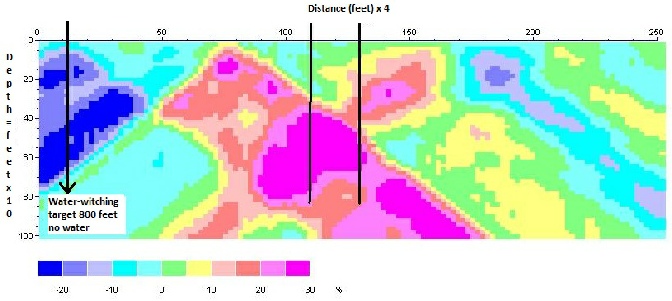
There is no standard with the geo-electric signature within geology and every now and than we receive anomalies that have no real
discernable target. When these types of anomalies
appear additional profiling is necessary.


References: WaterLocating.Com
Practical Geological II For the Exploration Geologist
REFERENCES RESEARCH:
Charles T. Young - Michigan Technological University
www.mtu.edu › ... › Geological and Mining Engineering and Sciences, Professor Emeritus.
http://water.usgs.gov/ogw/bgas/surface/
The location and orientation of fracture zones is important for modeling fluid flow and contaminant transport in fractured rocks. Surface geological methods are a rapid, inexpensive addition to drilling for determining the locations and orientation of fractured zones in bedrock. Surface geological can be used in conjunction with geologic, hydrologic, and borehole-geological investigations to optimize well siting (Jansen and Jurcek, 1997), or as a stand-alone method of fracture detection (Lewis and Haeni, 1987; Lieblich and others, 1991; Haeni and others, 1993).
Paterson, N. R., and V. Ronka, 1971, Five years if syrveying with the very low frequency electromagnetic method: Geoexploration, V. 9, p. 7-26.
Karous, M., and S. E. Hjelt, 1983. Linear filtering of VLF dip-angle measurements. Geological Prospecting, V. 31, p. 782-794.
Kulander, B. R., S. L. Dean, R. E. Williams, R. F. Fonner, P. Lessing, J. S.
McColloch, C. P. Messina, and J. H. Reynolds, 1980, Fracture Trends in the Allegheny Plateau of West Virginia: West Virginia Geological and Economic Survey.
Loke, M. N., 1998. RES2DINV Program for Resistivity Data. Privately published computer program.
Loke, M. N., and Barker, R. D., 1996, Rapid least-squares inversion of apparent resistivity pseudosection by quasi-Newton method. Geological Prospecting, V. 44, 131-152.
Mooney, H. M., 1958, A qualitative approach to electrical resistivity interpretation. Pure and Applied Geological, V. 40, 164-171.
Reynolds, J. M., 1997, An Introduction to Applied and Environmental Geological`: New York, NY, Wiley, 796 p.
deGroot-Hedlin, C. and Constable, S., 1990, Occams inversion to generate smooth, two-dimensional models from magnetotelluric data. Geological, V. 55, 1613-1624.

This computer target yielded 70 Gallons Per Minute (GPM)
This computer target yielded 30 (GPM)
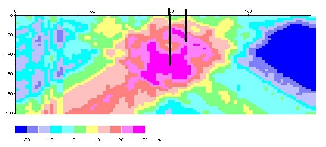
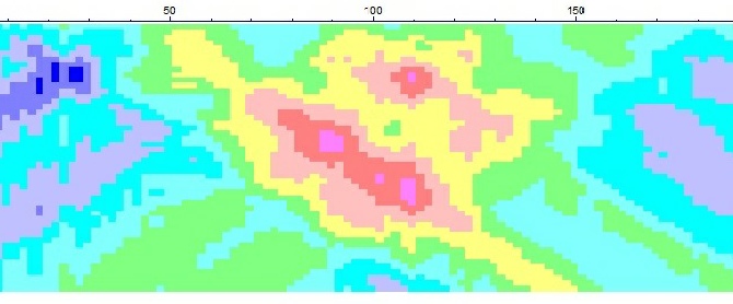
Extreme fracturing. These computer targets yield 500“+” gpm.
Only a very good driller will be able to develop this well
to the full vertical extent for high capacity gpm.
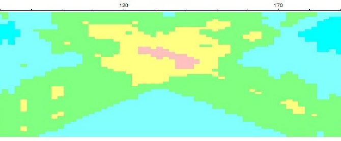
Average fracturing. This computer target yielded 150 (GPM)
You will need a very good driller to develop this well
to the full vertical extent for a high capacity well.
This computer target yielded approximately 35 (GPM).
This signature represents a tributary.
“Do Not Drill Blindly”
See “Technique”
This audio is the Result, 80%
of the time when you drill blindly.
Worthless seepage wells. Audio Click Me

Geological Interpretation
Radar Water has a staff with over 65 years of experience in water.
The interpretation of the computer-analyzed-generated cross-section profiles is reviewed and reported by a CA licensed Hydrogeologist. Analysis sent in a Pdf report to both the client and Radar Water for review of the drilling target.
Mr. David W. Abbott is now a Director and Officer of the Corporation, Technical Director, PG, CHg who has built his 40+ year career around applied groundwater hydrology and water supply wells.
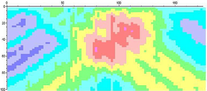
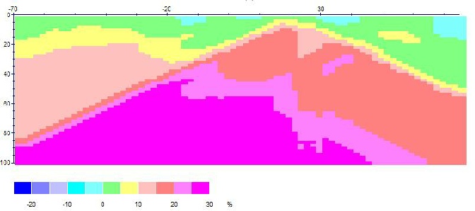
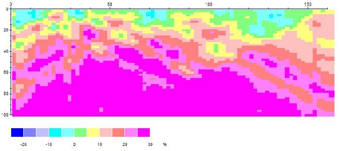
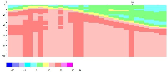
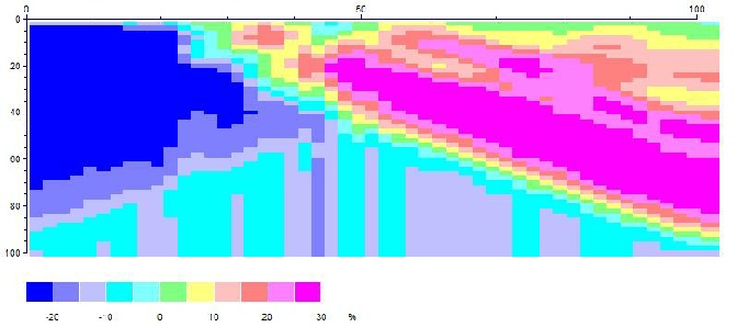
In layman’s terms, the horizontal color bar scale below the profile can be viewed as a measure of the rock density. The warmer colors that are to the right of zero correspond to potential drilling targets that likely represent multiple subsurface fractures that may contain water with a tolerance of +- 25 feet per one hundred feet of vertical depth.
If there is any water beneath your property,
it would collect more readily in porous / fractured earth.
For a good water well you need to drill into a fracture system that has a vertical extent of more than 50 feet for good gallons per minute (gpm).
For the better results (rather than just one software) we utilize a number of softwares (3-d in the making) and methods to extract more usable data that defines the subsurface signature.
Field analysis utilizes three (3) interpertations, normally two (2) different softwares are utilized for a much better target. Many geological formations are complicated, and to find your better signature, the more information to the hydrogeologists produces a better analysis. No charge.
How much water would you like?
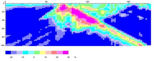
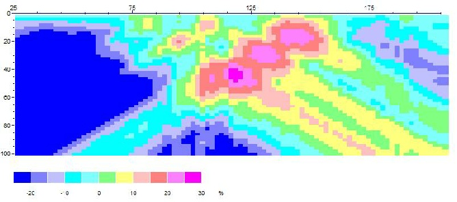
4 next similar profiles show a progression of increasing gallons per minute (gpm) from varying interstitial environments. Which one will satisfy your needs ?
Moderate “+” fracturing. Not drilled, profiled on 12-11-17.
This profile should produce 60 “+” GPM.
Minimum fracturing. Yield is 30 gpm by 300 feet.
This basic geometry yields a variety of gpm
depending on the degree of fracturing.