

**10 Advantages Unique to WaterLocating.Com's Technique**
Do not drill blindly!
Utilize computer generated drilling targets.
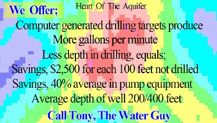
Point #1: No need to drill past 400 feet in depth 85% of the time with sufficient extracted geoelectric information.
See "Water Testimonials" for depth. You can save thousand of dollars in drilling expense and save hundreds in pump expense. Most water is within 200 to 400 feet when you drill in the heart of the aquifer or close to it.
Most water on the average is between 200 to 400 feet when you drill in the heart of the aquifer. The further away from the heart of the aquifer, the deeper you will have to drill in hope of striking water.
a) Qualitative assessment = thermometer reads 90 degrees.
b) Quantitative assessment = it feels around 98 degrees. A quesstimate.
2) For groves or anyone that requires a high capacity water well we make a quantitative assessment from the parameters, as to the posture of the aquifer's geometrics for a potential of gallons per minute that the aquifer system may produce. See
3) When the heart of an aquifer system is directly beneath your subsurface, that water system will be identified 100% of the time.
4) You will minimize the need to drill numerous wells to achieve your objectives. You will have a good idea 90% of the time, that your new well is in one of the most promising areas that was surveyed.
5) You can save thousands of dollars in drilling expense. Most of WaterLocatings.Com's computer drilling targets produce within 200 to 400 feet of drilling.
Not utilizing "WaterLocatings.Com's Computer Profiles", numerous wells, with marginal water, are drilled beyond 600 feet to 1000 feet or more.
See depths in GREEN Color coded.
6) "WaterLocatings.Com's Computer Profiles" will show what you are drilling into. A porous and or fractured zone or into a harder rock formation.
7) You will know the area of your property which is not that productive for water well drilling.
8) Normally there are two or more drilling targets within the "Computer Profiled area". They will be identified and labeled, then analyzed by a Certified Engineering Geologist as to which drilling target would be the number one choice to drill first.
9) For those that have an existing well or witched well that is a low producer. There is a 90% chance that you may have another area to drill with a potential that is greater in Gallons Per Minute.
10) Within the "Computer Profiles", you can see where the driller or water-
With this information, you will be more knowledgeable to make
"Informed Decisions”.
Only electronic computerized instrumentation can image the geometry of your subsurface and extract pertinent information from which "experienced analysis"
can pinpoint your water-
| Scientific |
| Sprinkler |
| Videos |
| Videos 1,2,3,4 |
| Vista Ca 2014 |
| Drillers Testify |
| Ramona Videos |
| Video 1 of 4 How It Works (Important) |
| Video 2 of 4 Lineament Analysis |
| Video 3 of 4 Water-Witching & EKS |
| Video 4 of 4 Aquifer Geometrics |
| Vista Video |
| Testimonial |
| San Diego |
| Riverside |
| Los Angeles |
| Alpine |
| Bonsall |
| Descanco |
| El Cajon |
| Escondido |
| Fallbrook |
| Jamul |
| Julian |
| Lakeside |
| Pauma Valley |
| Poway |
| Rainbow |
| Ramona |
| Santa Ysabel |
| Valley Center |
| Warner Springs |
| Ramona Video |
| Anza |
| Aguanga |
| Benton Area |
| Hemet |
| La Cresta |
| Murrieta |
| Perris |
| Temecula |
| Acton |
| Agua Dulca |
| Santa Clarita |
| Aquifers |
| San Diego |
| Riverside |
| San Bernardino |
| Los Angeles |
| Pivot Farms |
| About Us |
| Drillers Testimonial |
| Do's & Don'ts |
| Dud Wells |